Incomplete mapping often fails to represent the many dimensions of utility infrastructure. But utilities can now be mapped immediately with one push of a button using an app, which seamlessly integrates locating and mapping technologies.
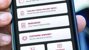
The free Subsite UtiliView utility mapping app allows users of the UtiliGuard 2 RTK locator to send utility data directly to their Esri map, which requires an annual subscription, without needing to download data transfer or convert files — steps that until now have been required to map utilities. This streamlining of mapping saves significant time and complications on locating jobs, according to Rodolfo Cabello, product manager for Subsite.
“The UtiliView app makes locate jobs easier and simpler to complete than ever, allowing users to add utility data to maps with one push of a button,” Cabello says. “The app eliminates much of the hassle that can come with locating and mapping utilities, requiring fewer steps than any other solution on the market, so both administrators and those on the job site can work more efficiently.”
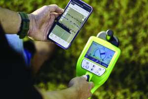
Using the UtiliGuard 2 RTK locator, technicians can get survey grade, centimeter-accuracy of utility locations. The utility data they capture can then be instantly transferred to an Esri map via the UtiliView app with the single push of a button on the locator.
Once utility data is collected, it can be accessed from anywhere — like by a technician in the field or a GIS administrator in a back office — all while being securely stored in a private environment. Photos can also easily be added to log points in the app for visual documentation and to create clearer, more complete records. And instant distance measurements can be generated to save time and improve record accuracy.
GIS administrators can set up the UtiliView app with a quick, one-time process. They can also add layers for gas, water, electric utilities and more. And they can make maps accessible with QR codes to promote uniformity across devices. Additionally, while some utility locators must be connected to a PC to be set up, the UtiliGuard RTK 2 locator can be ready to use as soon as the UtiliView app is downloaded on a mobile device. The app is available for Apple and Android devices.
800-846-2713; www.subsite.com
Continue reading for free