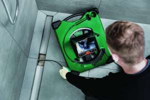
When integrated with Esri’s ArcGIS platform, WinCan VX sewer assessment software allows for navigation and analyzing of inspection data using a rich GIS interface. Map features can be linked to section and defect information, or a tabular record in an inspection can be clicked on to jump immediately to its mapped location. With this bidirectional link between GIS and WinCan, inspections can be prepopulated with data residing in GIS, eliminating manual data entry. The ArcGIS integration allows for filtered results, report creation, the browsing of media and the building of heat maps according to defect type or severity. 877-626-8386; www.wincan.com.
WinCan VX sewer assessment software
Jan 23, 2018
|