Order Digital Reprints
Sign Me Up!
Sign up Digital!
Subscribe to Print!
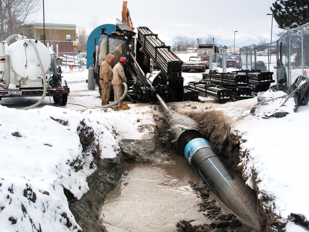
Bore planning software helps companies plan bores quickly and easily. (Photos and screenshots courtesy of Earth Energy)
Interested in Municipal/Industrial?
Get Municipal/Industrial articles, news and videos right in your inbox! Sign up now.
Municipal/Industrial + Get AlertsHorizontal directional drilling is challenging and difficult work fraught with unknown obstacles. While it’s not possible to eliminate every obstacle, bore planning software developed by drill manufacturers can help small and large contractors create a bore plan that minimizes risks.
Bore planning software was introduced 15 years ago. However, those basic programs helped contractors design only the pilot bore. While the software helped streamline the planning process, it was time-consuming and not widely used. Many contractors would just drill and hope for the best.
Today, bore planning software packages are more intuitive and user-friendly. The time to create a bore plan has shrunk dramatically, and the programs provide more information than ever about the bore and pullback. The software helps remove guesswork in determining elevations, and also in estimating the drill pitch for the pilot bore, the mud volume required and how hard the pipe will pull.
Much simpler
“These days, a contractor simply needs to gather the topographical elevations and required depth along the bore path, enter the data and hit Plan,” says Curt Dubbin, a trenchless solutions specialist with Vermeer. “The software will then produce a rod-by-rod plan of your bore.”
In the past, it seemed software tools were used only on the larger pipeline bores. That is changing as more contractors working on projects in the midsized range — 24,000 pounds and up — begin to use the tools for on-grade and profile bores.
Another reason for the increased popularity is the need to avoid existing underground facilities. “Bore planning tools can be used to help contractors develop a bore plan that will maintain proper separation distances between underground facilities,” Dubbin says.
“This is becoming ever so important as the vast amount of underground infrastructure continues to grow. Many of the software applications also allow users to create a permanent record of the completed bore that can be used as a reference to help generate more accurate bids on future jobs.”
Varied roles
There are a number of bore planning programs on the market, and each has a definite role in the planning process. Here is a quick summary of tools available to HDD contractors:
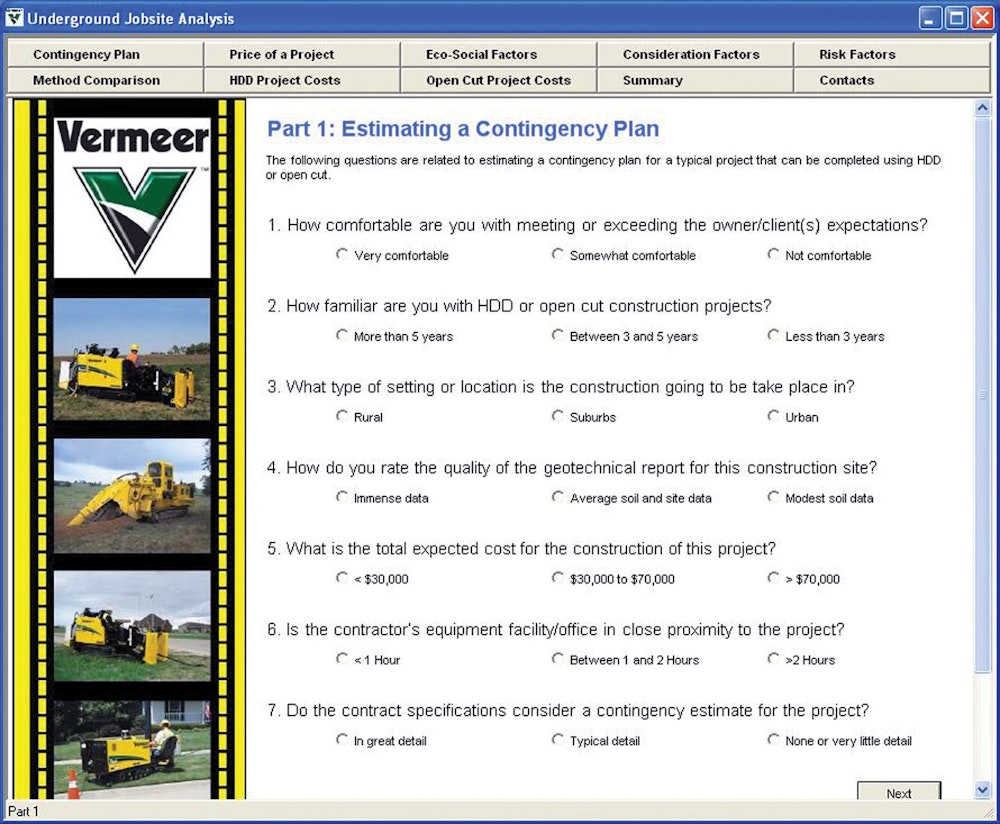
Analysis. Software programs can help contractors and engineers determine whether opencut trenching or HDD is appropriate for the installation. Nine aspects are considered, including customer expectations, contractor’s familiarity with technologies, project location, soil sample reports, competitors and risk factors. The software provides a detailed analysis and various considerations for choosing either method and explains the recommendation.
Preplanning. These tools help contractors select the appropriate drill and tooling based on the type of pipe to be installed and the anticipated soil conditions. Contractors can use a pulling load calculator to estimate the required pulling load for a specific HDD project based on the type of pipe, pipe diameter and total bore length. The calculator also recommends the appropriate drill size based on the bore specification entered for the project.
A soil classification guide helps contractors determine the site’s soil type and match the appropriate drill bit and backreamer. It also includes a fluid-mixing process map that shows how much mud should be used based on soil conditions, drill unit and tooling used.
Terrain mapping. This software is used in the survey phase where laser systems collect accurate topography and information about existing utilities along the bore route. In most applications, the information can easily be uploaded to the bore planning software.
Bore planning software. Using the data collected in the mapping phase, these programs provide a graphic visualization of the job, helping a crew see and perform the job from start to finish. By choosing drill stem diameter and length, the desired bore path depth, the desired minimum cover, and the diameter and allowable bend radius of the product pipe, the software plots a proposed bore path. The path is provided in two formats: one screen showing a top and side view and the other showing a report that lists the numerical depth and pitch of each drill stem. Once the bore is completed, the actual as-built depths can be entered into the designed profile and a comparison of design versus actual can be graphically shown.
In-field calculations. Any contractor knows things can change once they’re in the field, and a number of drill manufacturers also offer hand-held software tools just for those situations. These PDA devices can calculate setback distances, figure point-to-point bore paths, estimate pullback time and hole volumes, and configure the outside diameters of multiple ducts.
Changes on the horizon
While bore planning software has advanced by leaps and bounds in the past five years, manufacturers are constantly looking for ways to enhance their software packages. The trend is heading to more information.
“We are working to tie all of these applications into one complete package,” Dubbin says. “This will provide contractors with more in-depth information and data on proposed and completed bores. The software program will record everything from how hard the drill is working on a bore, to the mud pressures, to the amount of fuel consumed. A contractor will know exactly what happened on the bore and know the cost.”
With that kind of data on a project, contractors can increase their knowledge base and more accurately bid projects and manage their businesses. The integration will also make the planning process easier. Rather than jumping from one program to the next and then trying to bring it all back together into a cohesive piece, everything will be available in one place.
“Typically, contractors record data on only larger bores, but just imagine the competitive advantage a small to midsized contractor could have with this type of information,” Dubbin says. “It could make a significant impact on their business.”
Not just for contractors
While HDD contractors routinely use bore planning software, engineers are also getting on board. “I receive calls every week from engineers asking about our software programs,” Dubbin says. “They are using these tools to better plan underground installation projects that take into account a directional drill’s capabilities.”
The software will help engineers limit the risk of designing directional drill projects that are not mechanically feasible. For example, a plan based on too little data may call for a bend radius that is not possible with the pipe chosen or it may propose a machine that is underpowered for the project. In addition, the industry is asking for more on-grade boring, and the software can help engineers develop those projects in a realistic manner.
Furthermore, some communities require a formal plan to be submitted before a project starts. In Canada, an HDD contractor must submit a formal bore plan on all pipeline projects. Environmental guidelines do not allow for frac-outs on pipeline projects. Contractors must submit a plan that includes estimated mud pressures below ground and must have a plan in place to monitor downhole pressure to avoid potential frac-out situations.
Word of caution
Dubbin stresses caution when using bore planning tools, as unforeseen obstacles can always sidetrack a well-planned bore. “You can’t see what is happening down in the ground during a bore, so you never know what may happen. There are a lot of variables that a person can’t control, so it helps to be prepared.”
One factor that can be difficult to prepare for is changing ground conditions. Dubbin encourages drill operators to watch the returns on a pilot bore. The colors provide clues to the type of soil in which they’re working. If the returns are brown, then suddenly turn to dark brown, light white or gray, the drill is entering a different soil.
That soil type may require additional mud. For example, a contractor needs to pump three to four times as much mud into clay than into sandier soils, as it takes more force to remove the dirt particles from the hole. This is a condition that bore planning tools cannot predict.
Drilling in rock is also unpredictable, because a 20,000 psi rock drills much differently than a 42,000 psi rock. However, core samples along the bore path can be extracted and factored into the plan. This helps determine, rod-by-rod, when the drill enters and exits unique rock formations.
Bore planning software helps save contractors time and money. More important, it helps account for unforeseen challenges before they become a reality.
Bore Planning Software Has Evolved Over the Past 10 Years
Over the past decade, bore planning software and its acceptance in the horizontal directional drilling market continues to evolve. Bore planning software used to be available only on computers and had minimal PDA capabilities. Today, productivity tools like Vermeer Projects are available on smartphones, tablets, utility locating systems and on-rig displays. Also, more contractors are using bore planning software, including many smaller utility contractors. In some cases, utility companies now require bore planning documents before work begins. For many contractors, incorporating planning tools helps their crews operate more efficiently and allows them to provide professional documentation to their customers.
Designing a bore
According to Cory Mass, sales manager for Vermeer Intelligent Worksite Solutions, bore planning software is being integrated into every step of the drilling process. “Using a smartphone or tablet with a GPS antenna, contractors can walk the anticipated bore path, add points to the plan for existing utilities and then make adjustments from there. It’s much easier than it used to be.”
On the job
Once a plan has been reviewed, the bore plan can then be transferred to the HDD onboard display if crews are using a locating system designed to work with their software. With Vermeer Projects, the drill operator can use rod-by-rod information to track progress and any adjustments that were made from the original bore plan.
Also, using a GPS-enabled receiver, the drill locator can note landmarks around the area at the time of the bore to help identify buried utilities in the future. “Over time, things above ground can change dramatically, but what’s underground remains unchanged,” Mass says. “Capturing the distance between a landmark that is unlikely to change and the utility can help someone find it in the future.”
Documentation
After the bore is complete, users can compare and update the bore plan with as-built information. “Many utility companies require contractors to provide as-built bore profiles because it will help with future expansions or replacements,” Mass says. “As-built information will also help another contractor out as they’re planning to install product in the same area.”
With bore planning software like Vermeer Projects, the information collected during planning and execution can be stored in the system. Having this detailed historical information about what utilities are located where underground can also help reduce the number of utility strikes in the future.